Planning And Zoning Commission Releases Text Of Revised Data Center Ordinance
The Harrodsburg Herald/Robert Moore
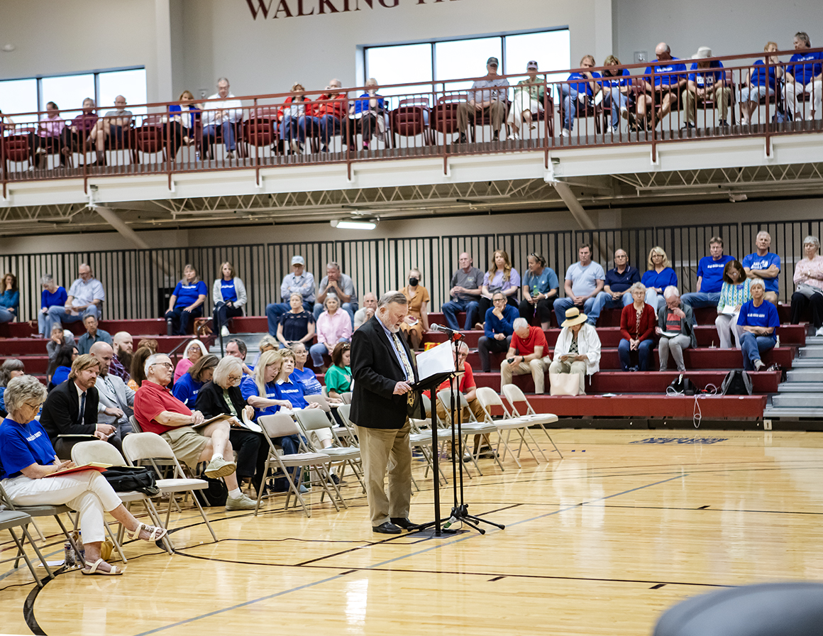
The Harrodsburg-Mercer County Joint Planning and Zoning Commission held a public hearing on Tuesday, April 28, to gather community input on proposed text amendments to local zoning ordinances regarding data centers.
Robert Moore
Herald Staff
[email protected]
Here is the unabridged text of the second draft of the proposed ordinance dealing with data centers drafted by the Harrodsburg-Mercer County Joint Planning and Zoning Commission.
The commission set a date for the public meeting on the proposed data center ordinance at 5 p.m. on Thursday, July 23, at the Campbellsville University Harrodsburg Campus gymnasium.
Click here to read a pdf of the revised draft.
You can also read the draft at the planning and zoning website.
I. INTRODUCTION
INDUSTRIAL TECHNOLOGY I-T – In compliance with the manifestation of the desire to protect prime farmland in the Comprehensive Plan, this Ordinance establishes suitable locations and comprehensive minimum standards for the siting, construction and operation of data centers in Mercer County and the City of Harrodsburg.
The Industrial Technology Zone (I-T) is intended not for manufacturing uses, but for emerging technology uses requiring large physical footprints, and not akin to other industrial or other uses.
A. Permitted uses in I-T districts:
1. Data center or small data center (such use shall be permitted for an applicant qualifying as a hyperscaler; or an entity who works directly with a hyperscaler and can demonstrate same.)
2. Utility. Electricity substations, transmission lines, and distribution needed to support an I-T district campus development may be sited in the I-T district, provided that siting of public facilities shall be in substantial accord with the Comprehensive Plan, as applicable.
B. Accessory uses in I-T districts:
1. Water treatment plant, publicly or privately owned, if approved by the Department of Public Works and incorporated into a Water Services Agreement approved by the City Commission after a public hearing;
2. Self-generating power infrastructure;
3. Utility-scale solar-generating facilities or power generation battery storage facilities where the solar or battery storage facility serves the principal use of a parcel within the I-T district;
4. Sewage treatment plant, publicly or privately owned, if approved by the Department of Public Works and incorporated into a Wastewater Services Agreement approved by the City Commission after a public hearing;
5. Elevated water storage tank or tower;
6. Small cell or roof-mounted telecommunications towers or facilities not in excess of height limitation specified below;
7. Central heating or cooling facility;
8. Food service facility similar to an employee cafeteria for service to employees or occupants of a secure facility not open to the general public;
9. Security building;
10. General storage and maintenance facility serving primarily the contiguous properties in common ownership;
11. Structured parking; and
12. General office serving primarily the internal administration or training of employees of contiguous properties in common ownership.
C. Definitions for I-T Zone
1. A “campus” is defined as an inter-connected network of physical facilities and cohesive perimeter buffers located within a contiguous geographic area governed by a unified site or masterplan whether in single or multiple ownership.
2. An “opaque buffer” is defined as an opaque screen from the ground to a height of at least six (6) feet. This type of buffer prevents visual contact between uses and creates a strong impression of total separation. Option 1 for opaque buffers shall be a minimum of twenty-five (25) feet and shall be composed of three (3) evergreen trees + four (4) ACI (“aggregate caliper inches”) of canopy trees + thirteen and one half (13.5) ACI of understory trees + twenty-three (23) shrubs per one hundred (100) linear feet. Option 2 for opaque buffers shall be a minimum of fifteen (15) feet and shall be composed of a six (6) foot tall opaque fence+ two (2) evergreen trees + four (4) ACI of canopy trees + fifteen (15) ACI of understory trees + twenty-three (23) shrubs per one hundred (100) linear feet.
3. Data centers are facilities used primarily for the storage, management, processing, or transmission of data and includes, but are not limited to, buildings designed to accommodate computer servers, storage systems, or specialized computing hardware. Examples include crypto processing, commercial cryptocurrency mining (bitcoin mining), artificial intelligence training and/or processing, and cloud-computing.
The following definitions enumerate the categories of data centers:
a) Enterprise Data Centers: Built, owned, and operated by companies for their own internal use, usually on-premise.
b) Colocation Data Centers (“Colo”): Facilities where organizations rent space, power, and cooling to house their own servers.
c) Cloud Data Centers: Off-premises services managed by third-party providers (e.g., Google Cloud, AWS) that host data and applications for multiple clients.
d) Managed Services Data Centers: Third-party providers manage the infrastructure, storage, and computing services directly for a client.
e) Edge Data Centers: Small, decentralized facilities located near end-users to reduce latency for real-time applications like IoT or 5G.
f) Hyperscale Data Centers: Massive, scalable facilities designed for cloud providers, often exceeding thousands of servers.
D. Requirements for all I-T – zoned parcels
1. As further set out below, a Water Services Agreement must be executed before any development in the I-T zone may submit site and building plans to Planning & Zoning.
2. As part of their rezoning application, applicants shall be required to execute a “Performance Agreement” [“Community Benefit Agreement”] on a form acceptable to the County and the City of Harrodsburg.
i. This agreement, among other subjects, shall address protections for ratepayers and their electric bills (including developer funding for infrastructure improvements necessary to minimize electric rate increases).
3. An Environmental Impact Assessment shall be required as part of any I-T Zone rezoning application, or any subsequent application related to an I-T zone use, including, without limitation, building permits, zoning permits, and development plan approvals or revisions. If the application/rezoning is approved, Assessments shall be submitted, updated, every six months during construction, and every year thereafter. The assessment shall be prepared by a third-party professional engineer, ecologist, environmental planner, or other qualified individual acceptable to the Planning & Zoning Commission. Any such assessment shall include a description of the proposed use, including its location and relationship to other projects or proposals, with adequate data and detail for the Planning Commission to assess the environmental impact of the proposed use. The assessment shall also include a comprehensive description of the existing environment and probable future effects of the proposal. This description shall focus on the elements of the environment most likely to be affected as well as potential regional effects and ecological interrelationships and shall also include a detailed examination of public resources most likely impacted by the Development. At a minimum, the assessment shall address the following:
a) Air pollution impacts from data center operations. The assessment shall identify all sources of fine particulate matter (PM2.5), volatile organic compounds, and nitrogen oxides at the data center as well as any other air pollution types regulated by state and federal agencies. The assessment shall specify best management practices for preventing and reducing polluting emissions at the data center. The owner and/or operator of the data center shall have anti-idling signs prominently posted in areas where ten (10) or more trucks may park or congregate;
b) Water pollution impacts from data center operations. The assessment shall identify all sources of microbes, toxic chemicals, physical pollutants, and radiological pollutants at the data center. The assessment shall specify best management practices for preventing and reducing water pollution emanating from the data center;
c) The potential for public nuisance to residents resulting from operations and truck traffic, including but not limited to noise, glare, light, and visual obstacles;
d) An erosion control/stormwater management plan compliant with any stormwater quality management plan adopted by applicable local, state, and federal laws and ordinances;
e) Consistency with the Comprehensive Plan. The assessment shall compare the impact of the proposed use to the Comprehensive Plan’s goals, objectives, and strategies. Where the proposed use conflicts with any part of the Comprehensive Plan, the assessment shall identify mitigation measures that may be undertaken to offset any degradation, diminution, or depletion of public natural resources;
f) A description of alternatives to the impact(s);
g) A statement of any adverse impact(s) that cannot be avoided;
h) A list of steps/structural controls proposed to minimize damage to the site before and after construction; and
i) Full and accurate identification of any critical impact area. A critical impact area is any area, condition, or feature that is environmentally sensitive or that, if disturbed during construction, would have an adverse impact on the natural environment. Such critical impact areas include but are not limited to floodplains, riparian buffers, streams, wetlands, slopes greater than fifteen percent (15%), highly acidic or highly erodible soils, hydric soils, hydrologic soil groups, areas of high-water table, and mature stands of native vegetation and aquifer recharge and discharge areas. An Environmental Impact Assessment shall state the impact of the proposed use on any critical impact area and all adverse impacts that cannot be avoided as well as all environmental protection measures, procedures, and schedules to be utilized to minimize damage to critical impact areas both during and after construction.
4. In addition to water and wastewater provisions herein, any data center project shall enter into a community benefit agreement to fund necessary community investments in increased staff and equipment for police/sheriff, fire, and EMS.
E. Development standards
The following additional development standards shall be required and provided for in the site plan and shall apply to all development and redevelopment within the I-T district inclusive of any of the foregoing permitted uses. In addition to recording approved site plans in the Office of the Mercer County Clerk, a recorded Certificate of Land Use Restriction shall set out applicable ongoing requirements, including, without limitation, the requirement set out below of reimbursing municipal engineer salary expenses, and any other conditions applied in conjunction with this Ordinance.
1. A viewshed analysis shall be submitted during the zone map amendment process. The analysis shall include three-dimensional imagery of the proposal and the surrounding buildings and properties to better understand how the proposed building will impact the nearby built and natural environment.
2. Minimum setback requirements and other dimensional standards.
a) Adjacent to residential zoning districts or residential uses and habitable structures: minimum setbacks shall be seven hundred fifty (750) feet.
b) Adjacent to planned unit developments: minimum setbacks shall be seven hundred fifty (750) feet.
c) Adjacent to agricultural zoning districts: minimum setbacks shall be two hundred fifty (250) feet.
d) Adjacent to commercial zoning districts: minimum setbacks shall be five hundred (500) feet.
e) Adjacent to industrial zoning districts: minimum setbacks shall be fifty (50) feet.
f) Adjacent to public streets: minimum setbacks shall be five hundred (500) feet.
g) Between buildings: Within a campus or other common scheme of development where individual lots or building sites are to be sited, the minimum setback between buildings on adjacent lots or building sites shall be twenty-five (25) feet. Covered walkways connecting buildings, or connecting buildings with parking areas or structures, shall be permitted in such setback areas. Driveways, parking, and covered entrances may be within the foregoing setback areas; however, no driveway may be closer than five (5) feet to any adjoining lot line, and parking and covered entrances shall follow setbacks set out in prior subsections above.
h) Building height. The maximum height shall be no more than fifty (50) feet.
i. Limitations.
• Appurtenances shall not interfere with Federal Aviation Regulations, Part 77, Objects Affecting Navigable Airspace;
• The appurtenance shall not be constructed for the purpose of providing additional floor area in the building; and
• The appurtenance shall comply with the screening requirements for mechanical equipment and appurtenances in this chapter.
ii. Similarly, the height of utility infrastructure shall be so restricted to the extent allowed by law.
i) Campuses in the I-T district shall encompass a minimum of three hundred (300) contiguous acres.
• Cumulative combined acreage zoned I-T in unincorporated Mercer County and the City of Harrodsburg, shall not exceed one thousand five hundred (1,500) acres. Data center campuses within Burgin city limits shall count against this cap.
• Additionally, I-T district campuses in unincorporated Mercer County shall be in areas suitable for industrial development including adequate existing or new infrastructure. Suitability shall include, without limitation, campuses falling entirely within an area defined by a radius of one and one half (1-1/2) miles emanating from the intersection of the eastern right-of-way of Curdsville Road and the main entrance to the E.W. Brown power plant property. Three-fifths (3/5), sixty percent (60 %) of the parcel proposed for development shall be within the one and one half (1-1/2) mile radius with all buildings (with the exception of gate guard shack) constructed entirely within the radius.
• Any lands zoned A-1 (representing prime farmland, whose preservation is called for in the Comprehensive Plan), as of the date of enactment of this Ordinance, shall not be eligible for rezoning to I-T.
4. Perimeter buffers.
a) All buffers may be situated within required setbacks, except for setbacks from state and federal highways.
b) Buffer yard plantings shall be designed to minimize visual impacts from adjacent public streets and properties not in common ownership. Notwithstanding the requirements of this section, use of natural topography and preservation of existing vegetation, supplemented by new vegetation and security fencing, may provide an alternative to new buffer yard plantings.
c) An Opaque Buffer shall be established and maintained with a minimum width of twenty-five (25) feet along the perimeter of each campus. In addition, additional plantings at a rate equivalent to an Opaque Buffer within the setback area but spread outside of the separately landscaped perimeter buffer shall be installed and maintained by the campus owner.
d) Buffers associated with each phase or incremental expansion of a campus must be shown on a landscaping plan submitted with each individual site plan. Vegetation that will remain on and is within a landscaping buffer provided on an easement on adjacent property may be used to satisfy the requirements of this subpart.
5. Landscaping.
a) A minimum of twenty percent (20%) open space shall be maintained for each campus or contiguous group of parcels in common ownership within the I-T district, including undeveloped land, wetlands, steep slopes, stormwater best management practice features, open areas, landscape buffers, and land used primarily for resource protection or recreational purposes.
b) The on-site open space requirement may be reduced, with prior approval, to ten percent (10%) on a parcel where all stormwater best management practices are designed to a two percent (2%) storm compliance and where all volume and nutrient treatment occurs on-site.
c) Landscaping elements must be shown on a landscaping plan prepared by a landscape architect, submitted with a site plan as part of a rezoning application.
6. Stormwater.
a) Applicant must submit a stormwater retention and management plan, prepared by a licensed engineer, with their site plan and rezoning application.
b) Any discharge to the waters of the Commonwealth must receive permitting and may require pretreatment.
c) Prior to issuance of a zoning permit or building permit, I-T zoned parcel landowners shall submit a Floodplain Impact Analysis including, without limitation, a No-Rise Certification, to evaluate how a project may affect existing flooding conditions in the hydraulically-connected area. The analysis and certification must be performed by an engineer, registered in Kentucky, and practicing within his or her area of expertise.
d) Applicants to rezone shall submit a subsurface investigation by developer’s Kentucky registered engineer to ensure that karst channels of groundwater are not interrupted; and to ensure the suitability for high load-bearing needed by the developer’s design team.
7. Noise. Any noise which emanates from operation or other activity associated with any data center or their accessory uses will be limited to a maximum volume in A-weighted decibels of sixty (60) dBA during the day (7:00 a.m. until 8 p.m.) and fifty-five (55) dBA at night (8:00 p.m. through 7:00 a.m.). Such levels shall be measured at the campus boundary. Activity within I-T district uses shall not emit persistent, repetitive noise. Notwithstanding the foregoing, the following activities and operations are exempt from the restrictions stated in this subpart:
a) Any person operating or causing to be operated any equipment used in construction, repair, testing, alteration, or demolition work on buildings, structures, or appurtenances thereto and/or testing of generators as required by any state or federal agency; although
b) Emergency operations, which for purposes of this section shall mean any situation arising from sudden and reasonably unforeseen events beyond the control of the facility operator, which requires the response of emergency vehicles or temporary use of emergency generators.
c) Generator testing conducted between 9:00 a.m. and 5:00 p.m., unless testing at a time outside of this range is required by state agency.
8. Noise Studies. A series of noise propagation studies shall be conducted and submitted to the Planning Commission as outlined herein.
a) The sound study shall be specific to the proposed site layout and building type, scale, and height shown on the site plan and shall evaluate (i) the noise conditions at the site prior to project development at set locations and set times of the year as determined by the County or City of Harrodsburg (as applicable) and (ii) provide model-predicted noise conditions resulting from the proposed project post-development.
1. The County and City reserve right, in a sound study, to evaluate noise conditions at those times reflecting extremes of noise levels for both pre-development and post-development study samples.
b) The sound study shall be prepared by a third-party professional engineer registered to practice in the Commonwealth in accordance with ISO 9613 standards and submitted to the County or City of Harrodsburg (as applicable) prior to issuance of final site plan approval.
c) The sound study shall include a comprehensive pre-disturbance sound study to include both A-weighted and C-weighted decibels, in daytime hours as well as night hours typical for sleep, recommendations for mitigation measures, and which mitigation measures, if applicable, should be incorporated into conditions of issuance of site plan approval. If mitigation measures are building-related, said mitigation measures shall be included in the building plans prior to issuance of building permit(s).
d) Post-development noise conditions at the campus boundary and/or at any habitable location within property within or adjacent to the I-T district will be evaluated and compared to the pre-disturbance sound study and all local requirements within sixty (60) days after the issuance of the certificate of occupancy for each phase and/or campus facility, and annually thereafter for a period of ten (10) years. There shall be no increase in sound levels, both A-decibels and C-decibels, from pre-disturbance levels, taken at five (5) locations constituting the data center’s nearest residential neighbors. Eighty percent of the five (5) locations (four (4) results if only five (5) sites are used) shall be used to determine compliance. Evaluations shall also be conducted, at the discretion of zoning staff, upon the receipt of complaints. Said evaluations shall be conducted by the campus operator at a time(s) generally known for peak data center cooling operations (annually between the months of June and August). In the event that the reports and/or evaluation or complaint-based testing at any habitable location within a receiving property shows that the use emanates sound which exceeds the maximum allowable decibel levels, then the operator shall immediately undertake all necessary efforts to mitigate any violation and in the event it refuses or fails to cure said violation, the County or City of Harrodsburg (as applicable) may exercise all legal avenues available recourse to obtain compliance shall be pursued. Planning & Zoning may act on behalf of these local governments as well. Local requirements for noise conditions shall include, without limitation.
9. Water Use and Waste/Stormwater Discharge.
a) General domestic water demand and sewer discharge shall be met by the utility, or utilities, serving, or possessing the right to serve, the site of the data center.
Cooling water shall be potable water provided by municipal water utilities, reuse water from municipal wastewater treatment plants, or water withdrawn from regulated waters of the Commonwealth.
b) As stated in Section D(1), a water services agreement (WSA), fully executed by the relevant parties, is required prior to any development, including land clearing, in the I-T zone and shall be submitted, fully executed, with site and building plans to the Harrodsburg-Mercer County Planning & Zoning Commission. The WSA is required whether process, cooling or sanitary-use water is provided, any or all, by any water utility, in production and conveyance, or only conveyance. The WSA shall be constructed and negotiated by a committee, consisting of a representative(s) of the water supplier, the conveyor/distributor of water, the Mercer County Judge Executive, the Mayor of Harrodsburg, and the Planning & Zoning Commission. The Judge and Mayor may designate a representative or proxy.
c) The WSA shall include provisions for collection and treatment of wastewater, if there is discharge to sewer utilities of cooling water, or any other waste-stream other than domestic sanitary (i.e., kitchenette and restrooms). Discharge of cooling water (contact or not) or other process water may require pretreatment prior to introduction into the publicly-owned treatment works (POTW). Any waste-stream discharged to the POTW shall be subject to city-ordained discharge limits.
d) The WSA shall include requirements, at the County or City’s sole discretion, and at least the following requirements:
i. That the data center developer shall finance and construct all of the reuse water cooling system or the necessary distribution upgrades and treatment plant expansions if potable water is used;
ii. That if temporary potable water for the data center cooling is used to bridge the time required to put the reuse system in operation, the County or City shall limit the daily quantity and period of use of said water, including both maximum and minimum volumes;
iii. Establishment for fees for availability and use of any reuse water cooling system;
iv. Confirmation of the available amounts of wastewater capacity to operate any reuse water cooling system and discharging requirements for the same;
v. The term for the WSA;
vi. Periodic reporting of water usage, recorded daily and submitted monthly;
vii. Enforcement action and penalties for action or lack of action which constitutes a violation of the WSA; and,
viii. Any other terms and conditions mutually agreeable to the County or City and the data center developer/operator.
e) The WSA shall further stipulate that any data center project shall fully fund all water and sewer infrastructure required to serve the project. Said infrastructure shall include, without limitation, treatment capacity for any potable water and wastewater that will be needed in a temporary and/or permanent capacity. (For example, if a data center will use one (1) million gallons of finished water a day at the peak of its consumption, whether during construction, ramp-up, or operations, it must provide the water and/or sewer utility with all the funds necessary to design, permit, and construct water and wastewater expansions at least that large.) The data center’s financial liability includes not only the cost described above, but also the present value of the annual depreciation for the life of the asset(s).
f) With respect to the use of potable water for cooling water for data center sites outside the Harrodsburg distribution system, a prerequisite determination shall be made by way of a cost of service study to quantify the cost upon any and all utilities, both in production and storage/delivery, to serve the data center. The providing utility shall contract with a registered engineering firm acceptable to all affected municipal and regulated utilities to conduct the cost-of-service study, the result of said study being technically-based cost(s) of serving the data center. Those costs shall be used in the construction of the WSA to ensure that no cost to serve the data center is charged or allocated to any other customers of the utilities.
g) The County and/or City, through their utilities, reserve the right to throttle or cap daily water usage in volumes consistent with the data center’s declared maximum demand. The data center shall be subject to the same drought period restrictions as any other commercial or industrial customers, as stated in the local Drought Management Plan and within the framework of the Kentucky Drought Mitigation and Response Plan.
h) The WSA shall adequately address potable water supply and distribution, including all utilities, both municipal and associations/districts regulated by the Kentucky Public Service Commission. The WSA shall be subject to a public hearing prior to adoption.
i) In the case of water withdrawn from, and discharges of stormwater or wastewater to the waters of the Commonwealth, the water withdrawal and KPDES permits, respectively, shall be as permitted by the Kentucky Division of Water and shall adhere to the volume limitations, testing requirements and discharge limitations as prescribed by the KDOW.
10. Fencing. Fencing of the property improvements may be located inside the buffer area. Fences may be up to eight (8) feet in height in all yards. No barbed wire fencing shall be permitted except on fences surrounding electrical substations.
11. Lot Requirements and Streets. I-T district developments may include private roads or commercial driveways with controlled and secured access. Private roads within a I-T district are exempt from applicable Zoning Ordinance or Subdivision Regulations’ street, block, and length development standards. Inter-parcel connection requirements may be waived if alternative emergency access areas are available.
12. Data centers shall not be accessed from City or County roads. Data centers shall only be accessed from State-maintained routes.
13. Lighting requirements.
a) On-site lighting shall comply with lighting standards set out in the Appendix below. Signage related to the permitted uses shall not be illuminated.
b) Parking lot or structures, access, and security lighting shall not exceed a height of twenty-five (25) feet.
c) Security entrance gate lighting shall not exceed a maximum illumination of fifteen (15) foot candles.
14. Minimizing air pollution particulate. On-site generators shall be equal or greater than the equivalent of Tier 4, pursuant to United States EPA standards.
15. Future transportation network. To the extent reasonably practicable, development within the I-T district will be encouraged to reserve adequate right of way area to support future connectivity of road infrastructure.
16. Power Source. Though I-T zone developments may install generators as back-up power sources in case of emergency, generators (mobile/portable or otherwise) shall not be used as the primary power source for I-T zone uses. All backup generation shall be housed in either impermeable sound buffer walls or inside of buildings.
17. Clean energy. To the extent reasonably practicable, all development within the I-T zone will be encouraged to strive for environmental sustainability, which may include among other initiatives a commitment to develop onsite renewable energy generation.
18. Nuclear energy sources shall require federal permit and compliance with all other applicable law.
F. I-T Zone differentiated surfaces, and use standards.
1. Any building facade visible from adjacent properties or public streets shall incorporate a differentiation that breaks the mass of the facade every 100 horizontal linear feet and no less frequent than 3 times the average height of the building by changes in at least 2 of the following design elements: building height, building facade step-back or recesses (minimum two and one half (2 ½) feet depth), fenestration, façade materials, pattern, texture, color, or use of accent materials.
2. Windows, doors, or similar fenestration design features such as faux windows must be distributed horizontally and vertically across the façade and comprise a minimum of five percent (5%) of each visible building façade.
3. The following elements may be included in the building design:
a) A main entrance feature that is differentiated from the remainder of the façade;
b) High albedo or light-colored roof;
c) Enclosures for on-site generators; and
d) Shrouds for any exhaust stacks.
4. Building façade material requirements.
a) Primary facade materials shall be limited to one or more of the following: tinted textured masonry block, pre-cast concrete, tilt-up concrete panels, brick or stone veneer, stucco and external insulation finish system that simulates a stucco appearance, metal panel systems, structural metal siding, or smooth-faced concrete blocks. All metal panels shall be fully engineered, architectural quality systems. Facades shall match color schemes associated with Shaker Village;
b) Accent or trim building materials may include any of the primary facade materials, wood, fiber cement, vinyl, or composite trim.
5. All ground level and rooftop mechanical equipment and all electrical equipment, electrical yards, or electrical switching stations shall be screened from adjacent properties and public streets by one of the following: solid fencing, parapet walls, or an opaque landscaping buffer with a majority of evergreen trees.
6. Screening during construction shall be addressed in a screening plan submitted with the site plan.
7. A water-based cooling system associated with a data center shall be evaluated to determine whether existing public water and sanitary sewer conveyance and treatment facilities are adequate for the proposed use; and whether there is sufficient water capacity available to supply the proposed use. All system upgrades costs shall be borne by the developer.
8. Upon approval of any zone change, a data center developer shall escrow fifty million dollars ($50,000,000.00) in an interest-bearing account, bearing interest at three percent (3%). Interest from this account shall fund development-related expenses including, without limitation:
a. Any data center project over one hundred megawatts (100MW) of capacity shall pay, out of the aforementioned interest, the salary of full-time engineer and inspector positions annually, at a minimum level of two hundred thousand dollars ($200,000) not to exceed three hundred thousand dollars ($300,000) (subject to inflationary adjustment), in perpetuity, or until decommissioning is complete. This requirement shall survive regardless any changes in facility ownership and occupancy, and is intended to provide accountability and added capacity for reviewing development documents.
b. Violation penalties related to data center development, as further set out herein.
9. All construction and trucking activities during facilities buildout shall adhere strictly to County quiet hours ordinances, and developer/data center shall maintain and repair all city and county roads within three (3) miles of the job site at their own expense and in line with County Road Department and Kentucky Transportation Cabinet recommendations. Construction traffic shall be coordinated with local Boards of Education so as to avoid hours of school bus travel.
II. DECOMMISSIONING AND FINANCIAL ASSURANCE
A. Trigger for Decommissioning
Decommissioning shall be initiated upon the earliest of:
1. Cessation of operations for twelve (12) consecutive months, or
2. Written notice by the owner of intent to abandon, or
3. Revocation/expiration of required permits without active use
a. After Cessation or the commencement of decommissioning, an operator may resume data center operations after approval of a zoning permit.
4. Planning & Zoning, upon determining that decommissioning has been triggered under a condition herein, shall give notice of its determination to the operator.
a. The operator shall have forty-five (45) days after issuance to offer any rebuttal in the form of:
i. Evidence of financial viability, or
ii. Other proof of continued operations.
B. Decommissioning Plan (Karst Considerations)
Prior to issuance of a building permit, the applicant shall submit a Decommissioning Plan for approval that includes:
1. Removal of all buildings, equipment, fuel systems, and impervious surfaces (unless otherwise approved)
2. Disposal of all materials related to removal in accordance with all applicable laws
3. Restoration of the site to a stable, graded, and vegetated condition suitable for future use
4. Identification and proper closure of subsurface structures, voids, or engineered fill zones
5. Detailed evaluation of karst features, including sinkholes, solution channels, and subsidence zones
6. Cost estimate prepared and stamped by a licensed professional engineer
C. Financial Assurance
1. The owner/operator shall provide financial assurance in the following forms of Cash escrow of one hundred million dollars ($100,000,000), or as approved by the Mercer County Fiscal Court or Harrodsburg City Commission in an amount that:
a) Shall equal one hundred fifty percent (150%) of the estimated decommissioning cost due to karst uncertainty
b) Must be reviewed and updated every three (3) years (or sooner if expansion occurs)
2. The County or City (either may act through Planning & Zoning) may draw upon the security described in this section if the owner fails to complete decommissioning, or to commence decommissioning within ninety (90) days of the “triggers” described in this section. Planning & Zoning shall give thirty (30) days’ written notice prior to any draw on the Security. If the owner fails to commence decommissioning after these thirty (30) days, the County, City or Planning & Zoning may:
a) Enter the property
b) Complete decommissioning and stabilization
c) Recover costs from the financial assurance
3. Security shall be released upon County or City motion approving completion of the Decommissioning Plan, as further described in this section.
D. Karst Liability
1. The owner/operator shall retain full responsibility for any subsidence, sinkhole formation, or groundwater impacts associated with the facility, both during operation and post-decommissioning.
2. Liability shall run with the land and shall not be extinguished by transfer of ownership without County or City approval.
E. Groundwater Protection
All decommissioning activities shall:
1. Prevent contamination of karst aquifers
2. Include groundwater monitoring where risk is identified
3. Remove or remediate any contamination from fuels, coolants, or battery systems
F. Post-Closure Monitoring
1. The owner/operator shall conduct post-decommissioning monitoring for a period of no less than five (5) years to evaluate:
a) Ground stability
b) Sinkhole formation
c) Groundwater quality
2. Reports shall be submitted annually to the County or City.
G. Final Certification
1. Following the “post-closure monitoring” period described above, a licensed professional engineer, licensed in the Commonwealth of Kentucky, shall certify that:
a) Decommissioning is complete pursuant to the Decommissioning Plan.
b) Site is stable relative to karst conditions
c) No ongoing environmental hazards remain
2. With the certification described in this subsection, the County or City shall, upon motion approve completion of the Decommissioning Plan.
III. ENFORCEMENT, CORRECTIVE ACTION, AND PENALTIES
A. Penalties for Zoning Ordinance Violations
1. In light of the substantial impacts posed by data centers, penalties for data center Zoning Ordinance violations or violations of zone change conditions or other land use restrictions shall carry a penalty of twenty thousand dollars ($20,000.00) per day until remedied.
2. For citizen complaints regarding data center operation, the framework below for arbitration shall apply. Planning & Zoning shall have its choice of remedies, or the application of both penalty fines and arbitration.
B. Arbitration and Contact Requirements
1. All complaints regarding data centers shall be logged by the data center owner. At minimum, the log shall describe the name and address of the complainant, contact information of the complainant, when the complaint is received, a detailed description of the nature of the complaint, action taken to resolve the complaint, and the date the complaint is resolved. If any complaint is considered by the data center owner to not be the responsibility of the data center owner, a reason shall be provided to the complainant and so noted on the log. The log must be sent to the zoning administrator at a frequency no less than twice per year. Upon receipt of a formal complaint, the data center owner shall be responsible for conducting a special focused study to ascertain facts associated with the study to address the concern of the complainant and shall be financially responsible for the study. The firm that conducts the complaint generated study must be different than that of the firm that conducted any pre- and post-construction studies and must also be accredited. If the data center owner takes no action on a complaint, the zoning administrator may pursue criminal prosecution if investigation reveals a zoning violation.
2. If after sixty (60) days there is no resolution of a registered complaint, the complainant may provide notice to the zoning administrator accompanied by an arbitration fee of five hundred dollars ($500) that they intend to enter into binding arbitration of the unresolved complaint. Failure by the data center owner to perform an action specified by the arbitrator will be considered a violation of the Zoning Ordinance and subject to the applicable enforcement penalties and remedies. For cases in which the arbitration ends with a decision in favor of the complainant, the complainant shall be refunded the arbitration fee. Upon receipt of a request for arbitration the zoning administrator will arrange for a time and place to meet with the arbitrator. Upon approval of a data center project the data center owner shall continually fund a non-reverting fund (for arbitration only), which will contain no less than five thousand dollars ($5,000.00) at any time, for the life of the data center project. Notification by certified mail of a deficiency in the balance of the fund to the operator shall be the responsibility of the zoning administrator. If upon notification that the fund is deficient, the data center owner shall have sixty (60) days to bring the fund back to the prescribed minimum amount. If the payment is not satisfied within the sixty (60) days, the data center project will be deemed in violation of the permit. The arbitrator shall be a member of the Kentucky Bar Association, be on the Roster of Court-Approved Mediators in the State of Kentucky, and shall not be a citizen of the City of Harrodsburg or Mercer County, Kentucky. The zoning administrator may appear and present evidence on behalf of a complainant if requested to do so.
C. Emergency Contact Information
Each data center shall provide twenty-four (24) hour emergency contact signage visible at the access entrance. Signs shall include the company name (if applicable}, the owner, operator, and/or representative’s name, the telephone number, and the corresponding local power company’s name and telephone number.
D. Community Liaison Contact Information
Each data center shall provide twenty-four (24) hour community liaison signage visible at the access entrance. Signs shall include the company name (if applicable), the owner, the operator, and the community liaison’s name and telephone number. The community liaison is the data center’s representative for non-emergency contact, such as for complaints. The emergency contact and the community liaison may be the same person as long as the signage reflects such.
APPENDIX
A. Purpose and intent. The purpose of this section is to regulate light spillage and glare to ensure the safety of motorists and pedestrians, and to ensure lighting does not adversely affect land uses on adjacent lands. More specifically, this section is intended to:
1. Regulate lighting to assure that excessive light spillage and glare are not directed at adjacent lands, neighboring areas, and motorists;
2. Ensure that all site lighting is designed and installed to maintain adequate lighting levels on site;
3. Provide security for persons and land.
B. Applicability.
1. General. The provisions of this section shall apply to all development in the City, as well as to I-T zone development in unincorporated Mercer County.
2. Time of review. Review for compliance with the standards of this section shall occur as part of the review of an application for a site plan, planned development, certificate of appropriateness, or certificate of zoning use, as appropriate by the development administrator.
3. Existing development. Compliance with these standards, to the maximum extent practicable, shall also apply to redevelopment of an existing structure, building, or use when it is expanded, enlarged, or otherwise increased in intensity equivalent to or beyond fifty percent (50%).
4. Exemptions. The following uses, activities and development are exempt from the exterior lighting standards of this section:
a) FAA-mandated lighting associated with a utility tower or airport;
b) Lighting associated with navigational beacons, the United States flag, or Kentucky flag;
c) Holiday lighting during the months of November, December, and January, provided the lighting does not create unsafe glare on street rights-of-way;
d) Battery-powered emergency lighting; and
e) Architectural lighting of four hundred fifty (450) lumens (= forty (40) watts incandescent) or less.
C. Lighting plan.
To ensure compliance with the standards of this section, a lighting plan prepared by a lighting engineer demonstrating how exterior lighting will comply with the standards of this section shall be included as part of every development approval application. D. General standards.
1. Hours of illumination. Institutional uses, commercial uses, and industrial uses that are adjacent to existing residential development shall extinguish all exterior lighting — except lighting necessary for security or emergency purposes — between the hours of 8:00 p.m. and 7:00 a.m. For the purposes of this subsection, lighting “necessary for security or emergency purposes” shall be construed to mean the minimum amount of exterior lighting necessary to illuminate possible points of entry or exit into a structure, to illuminate exterior walkways, or to illuminate outdoor storage areas. Lighting activated by motion sensor devices is strongly encouraged.
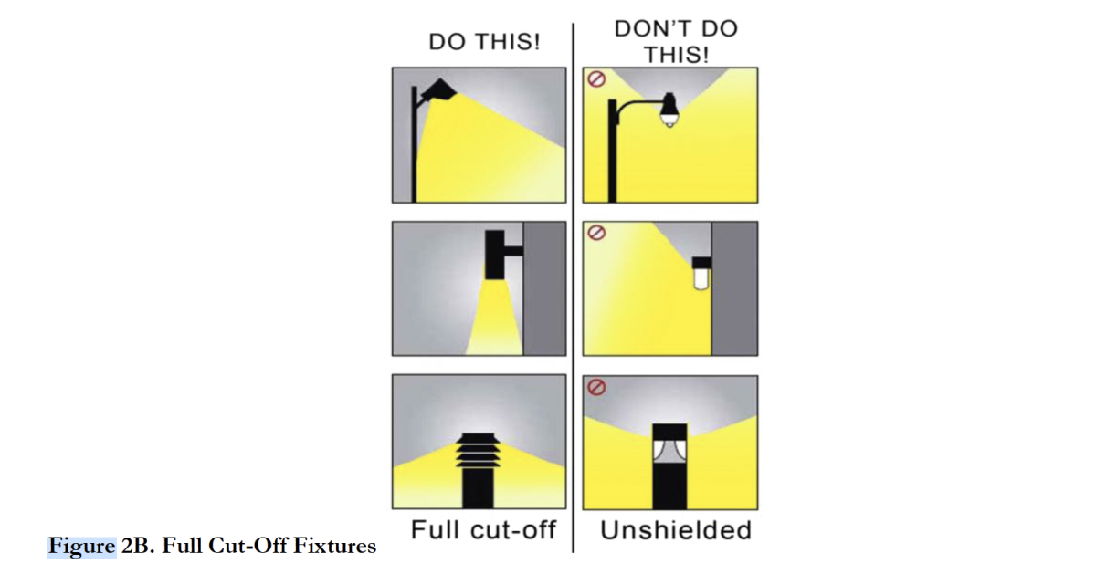
2. Shielding. Except for single-family detached and duplex dwellings, all exterior luminaries, including security lighting, shall be full cut-off fixtures and directed downward, consistent with Figure 2B, Full Cut-Off Fixtures. In no case shall lighting be directed above a horizontal plane through the lighting fixture.
3. Maximum height.
• The height of outdoor lighting, whether mounted on poles, walls, or by other means, shall be no greater than twenty-five (25) feet above grade.
4. Maximum illumination value.
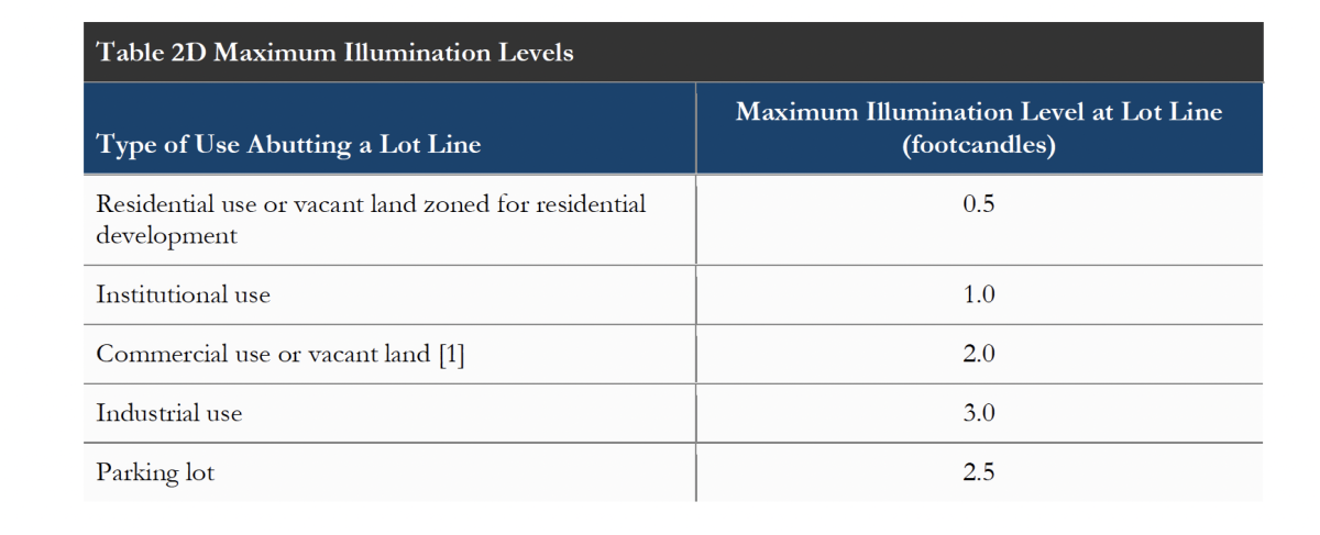
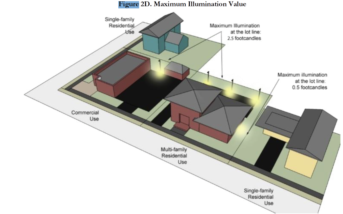
a. All outdoor lighting and indoor lighting visible from outside shall be designed and located so that the maximum illumination measured in footcandles at ground level measured at any lot line shall not exceed the standards in Table 2D, Maximum Illumination Levels, and Figure 2D Maximum Illumination Value. Table 2D Maximum Illumination Levels Type of Use Abutting a Lot Line Maximum Illumination Level at Lot Line (footcandles) Residential use or vacant land zoned for residential development 0.5 Institutional use 1.0 Commercial use or vacant land [1] 2.0 Industrial use 3.0 Parking lot 2.5
NOTES:
[1] Includes mixed-use development
b. In no instance shall illumination levels within a lot or development site exceed three (3) footcandles.
5. Signage. Lighting for signage shall be prohibited.
G. Measurement.
1. Light level measurements shall be made from a lot line of the land upon which light to be measured is being generated. If measurement on private property adjacent to the light-generating land is not possible or practical, light level measurements may be made at the boundary of the public street right-of-way that adjoins the land.
2. Measurements shall be made at established grade (ground level), with the light-registering portion of the meter held parallel to the ground pointing up. The meter shall have cosine and color correction and have an accuracy tolerance of no greater than plus or minus five percent (5%).
3. Measurements shall be taken with a light meter that has been calibrated within two years. The development administrator shall be responsible for enforcement of the standards in this section.